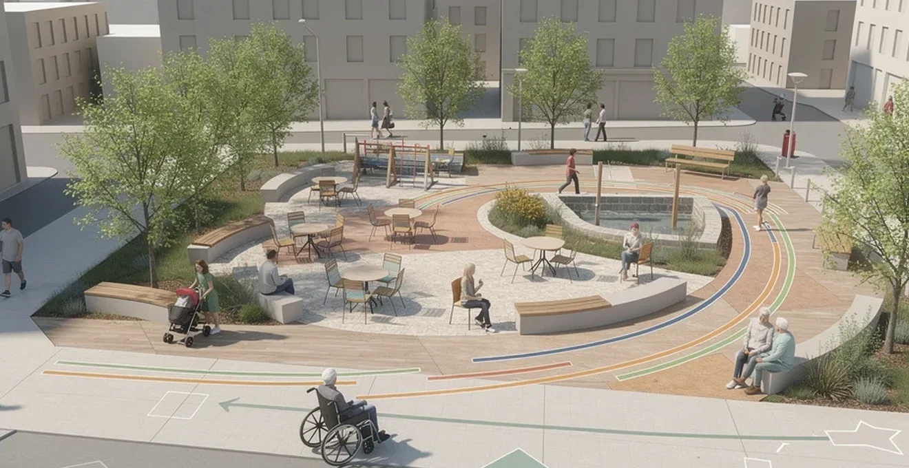
Public space shapes how people experience a city long before they notice the buildings around it. A well-designed street, plaza or park invites people to linger, meet, and move safely, while a poorly conceived one leaves them exposed, disoriented or simply absent. Human-centred design puts these lived experiences at the centre of planning decisions, rather than treating people as an afterthought to traffic engineering or land-use zoning. This guide sets out the frameworks, diagnostic tools and design considerations that practitioners use to create spaces that genuinely respond to how people see, hear, move through and inhabit their surroundings. It draws on established methodologies from landscape architecture, environmental psychology and urban design practice, and looks at how cities including Copenhagen, New York, Melbourne and Barcelona have applied these principles at scale.
What defines Human-Centred design in public space planning
Human-centred design in public space planning means starting with observed human behaviour and sensory experience, rather than with abstract design principles or purely technical requirements. It asks how a space feels to walk through, sit in or wait within, and treats those answers as design data rather than subjective opinion. This approach recognises that people connect with places differently depending on age, ability, culture and circumstance, so a genuinely human-centred space must offer a range of sensory and social qualities rather than a single, uniform experience.
Jan gehl’s « life between buildings » framework and its modern applications
Danish architect Jan Gehl argued that the space between buildings, not the buildings themselves, determines whether a city feels alive. His framework distinguishes between necessary activities (commuting, running errands), optional activities (sitting, strolling, people-watching) and social activities (conversations, children playing, communal events). Gehl’s central insight is that optional and social activities only flourish when the physical environment supports them: comfortable seating, protection from wind and traffic, and a human scale of buildings and streets. Contemporary practice applies this by auditing streets and squares for how well they accommodate slow, voluntary use rather than simply measuring pedestrian throughput.
The twelve quality criteria for public space assessment
Gehl’s methodology is often distilled into twelve quality criteria, grouped under three broad headings: protection, comfort, and enjoyment. Protection covers safety from traffic and crime, and shelter from unpleasant weather. Comfort addresses opportunities to walk, stand, sit, see, hear and talk, along with play and exercise possibilities. Enjoyment relates to human scale, opportunities to enjoy positive climate aspects, and aesthetic quality. Practitioners use these criteria as a checklist during site assessment, scoring existing conditions against each point to identify where a space falls short before proposing interventions.
Placemaking versus Place-Shaping: key distinctions for practitioners
Placemaking and place-shaping are often used interchangeably, but the distinction matters for practice. Placemaking, as promoted by organisations such as Project for Public Spaces, tends to focus on community-led, often incremental activation of specific sites, built around local knowledge and grassroots participation. Place-shaping is a broader, more strategic process, typically led by local authorities, that considers how policy, infrastructure investment and long-term planning decisions collectively shape an area’s identity and function. In practice, the two approaches complement one another: place-shaping sets the strategic conditions, while placemaking delivers the fine-grained, community-responsive detail within them.
William H. whyte’s behavioural observation methods in contemporary practice
William H. Whyte’s direct observation of how people actually used New York’s plazas remains foundational to public space analysis. His method involved watching, filming and recording where people chose to sit, gather or avoid, rather than relying on stated preferences. This behavioural approach underpins much of today’s site analysis practice: planners still observe where people pause, which routes they choose over designated paths, and which edges of a space attract lingering activity. The core principle endures because it treats behaviour, not intention or design theory, as the most reliable evidence of what a space actually offers.
Site analysis and diagnostic tools for Human-Centred interventions
Before any redesign begins, practitioners need a clear, evidence-based picture of how a space currently functions. Diagnostic tools range from structured observational surveys to computational movement modelling, each offering a different layer of insight into how people actually use a place.
Conducting a public life survey using gehl institute methodology
A public life survey systematically records who is present in a space, what they are doing, and where activity concentrates or thins out. Surveys typically capture pedestrian counts at set intervals, stationary activity mapping (where people stop, sit or gather), and qualitative notes on the character of interactions observed. Repeating surveys at different times of day and across seasons reveals how a space’s use shifts with light, temperature and programming, giving planners a baseline against which to measure the impact of future interventions.
Space syntax analysis for pedestrian movement patterns
Space syntax analysis examines how the configuration of streets and spaces influences movement, using computational models of connectivity and visibility to predict pedestrian flows. It helps planners understand why some streets attract footfall naturally while others, despite similar amenities, remain underused. This analysis is particularly useful at the early masterplanning stage, before physical interventions are tested, because it identifies structural issues in a street network that no amount of surface-level design can fully resolve.
PPS (project for public spaces) place diagram application
The Place Diagram, developed by Project for Public Spaces, evaluates a location against four key attributes: sociability, uses and activities, access and linkages, and comfort and image. Each attribute is assessed through both measurable indicators, such as crime statistics or land use mix, and more intuitive qualities, such as whether a place feels welcoming or diverse. The diagram gives practitioners a structured way to diagnose specific weaknesses in a space and prioritise which attribute needs the most attention.
Mapping desire lines and informal pedestrian behaviour
Desire lines, the informal paths worn into grass or gravel by repeated pedestrian shortcuts, are one of the clearest signals of a mismatch between designed infrastructure and actual behaviour. Mapping these paths, alongside other informal behaviours such as jaywalking patterns or unofficial seating spots, gives planners direct evidence of where people want to move or gather, regardless of what the original design intended. Rather than resisting these patterns, human-centred design incorporates them, formalising a well-used desire line into a proper path rather than fencing it off.
Designing for sensory comfort and microclimate regulation
People’s willingness to stay in a public space is strongly influenced by physical comfort: whether it is too hot, too cold, too windy, or too loud. Designing for sensory comfort means treating microclimate and acoustic conditions as core design parameters rather than incidental site constraints.
Thermal comfort modelling in temperate and continental climates
Thermal comfort modelling assesses how sun exposure, shade, surface materials and airflow combine to affect how a space feels across the seasons. In temperate and continental climates, this often means balancing the need for winter sun penetration against summer overheating, using strategically placed trees, canopies or building orientation to modulate exposure through the year. Paving material choice also matters: hard, dark surfaces absorb and re-radiate heat, while permeable or lighter-coloured materials help moderate surface temperature.
Acoustic zoning strategies for urban plazas
Acoustic zoning involves deliberately separating or buffering areas of a plaza according to their intended activity, so that quiet seating areas are shielded from traffic noise or high-activity zones such as play areas or markets. This can be achieved through physical means, such as planting, level changes or building placement, or through spatial layout that keeps noisy and quiet functions at a comfortable distance from one another. The aim is to give users a genuine choice between stimulation and calm within the same space.
Wind tunnel testing and building massing considerations
Tall buildings can create uncomfortable or even hazardous wind conditions at ground level, particularly where wind is funnelled or accelerated around building corners. Wind tunnel testing, whether physical or computational, allows designers to assess these effects before construction and adjust building massing, podium design or landscaping to mitigate turbulence. This is a critical but often overlooked element of human-centred design, since even a well-programmed plaza will fail if wind makes it physically unpleasant to occupy.
Inclusive accessibility standards beyond regulatory compliance
Meeting minimum accessibility regulations is a starting point, not an end goal. Genuinely inclusive public space design considers the full range of human ability, age and lived experience, going beyond compliance to ask whether a space is truly comfortable and dignified to use for everyone.
Universal design principles applied to streetscapes
Universal design aims to create environments usable by the widest possible range of people without the need for specialised adaptation. Applied to streetscapes, this means level or gently graded surfaces, adequate turning space for wheelchairs and pushchairs, clear sightlines, and seating placed at regular intervals to support those with limited stamina. Rather than designing separate accommodations for different needs, universal design seeks solutions that work well for as many users as possible from the outset.
Tactile paving and wayfinding for visually impaired users
Tactile paving provides underfoot cues that help visually impaired pedestrians navigate crossings, platform edges and changes in level safely. Effective wayfinding for this group also depends on consistent, predictable placement of tactile surfaces, complemented by audible signals at crossings and clear, high-contrast signage for those with partial sight. Inconsistent application of these elements across a city undermines their usefulness, so coordination across projects and departments is essential.
Age-friendly city frameworks following WHO guidelines
Age-friendly city frameworks consider how public space needs change across the life course, with particular attention to the needs of older residents. This includes sufficient, well-placed seating, adequate crossing times at signals, accessible public toilets, and pavements free of trip hazards. These frameworks recognise that designing for older people’s needs, such as rest points on longer walking routes, tends to benefit a much wider range of users, including parents with young children and people with temporary mobility impairments.
Gender-responsive urban design practices from vienna’s Frauen-Werk-Stadt
Vienna’s Frauen-Werk-Stadt housing development was designed explicitly around the everyday routines of women, particularly those balancing paid work with caregiving responsibilities, incorporating features such as childcare facilities, good sightlines, and layouts that support the shorter, more frequent trips typical of caregiving journeys. Gender-responsive design more broadly considers how public space safety and usability differ by gender, including addressing the disproportionate impact of harassment and safety concerns on women’s use of public space, through measures such as improved lighting, clear sightlines, and the careful placement of seating and public realm furniture.
Case studies in successful Human-Centred public realm transformation
Several cities have applied human-centred principles at meaningful scale, offering practical lessons for planners considering similar interventions.
Copenhagen’s strøget pedestrianisation strategy
Copenhagen’s Strøget, pedestrianised in phases beginning in the 1960s, is widely regarded as one of the earliest and most influential examples of deliberate pedestrian-priority street design in a major European city. Its gradual, phased approach, closely studied and adjusted based on observed public life, became a model for the incremental method that Jan Gehl later formalised into broader planning practice. The transformation demonstrated that removing vehicle access, when paired with careful attention to seating, activity and street life, can significantly increase pedestrian use over time.
New york city’s times square plaza conversion under the department of transportation
New York City’s Department of Transportation converted vehicle lanes in Times Square into pedestrian plazas, initially using low-cost, temporary materials such as paint and moveable furniture to test the intervention before committing to permanent redesign. This tactical, phased approach allowed the city to gather real-world usage data and public feedback before investing in permanent infrastructure, reducing risk and building public and political support for the change.
Melbourne’s laneway revitalisation and activation policy
Melbourne’s transformation of its once-neglected laneways into vibrant pedestrian routes lined with cafes, art and small businesses is a widely cited example of activating overlooked urban space through policy support for small-scale, ground-floor activity. The approach relied on encouraging diverse, fine-grained uses at street level rather than large single interventions, allowing the character of each laneway to develop organically over time.
Barcelona’s superblock (superilla) model for Neighbourhood-Scale redesign
Barcelona’s superblock model reorganises groups of existing city blocks so that through-traffic is restricted to the perimeter, freeing the interior streets for pedestrians, cyclists and community activity. This neighbourhood-scale approach addresses several human-centred priorities simultaneously: reducing traffic noise and air pollution, reclaiming street space for social use, and improving safety for children and older residents, without requiring wholesale demolition or rebuilding of the existing urban fabric.
Implementation frameworks and stakeholder engagement methodologies
Even the best-diagnosed design intervention depends on how it is implemented and who is involved in shaping it. Human-centred implementation methods favour testing, iteration and genuine community involvement over one-off, top-down delivery.
Tactical urbanism and Low-Cost pilot interventions
Tactical urbanism uses temporary, low-cost materials, such as paint, planters and moveable furniture, to trial a design change before committing to permanent construction. A parking space might become a parklet for a trial period, or a street might be closed for a monthly event, allowing planners to observe real usage and gather feedback with minimal financial risk. This approach shifts the traditional planning process, which often involves years of studies and proposals before any physical change occurs, towards a more iterative, evidence-based cycle of prototyping and refinement.
Co-design workshops using participatory action research
Participatory action research involves residents directly in identifying problems, generating design options and evaluating outcomes, rather than treating them solely as consultees responding to finished proposals. Co-design workshops structured around this approach typically combine mapping exercises, scenario testing and iterative feedback sessions, positioning local knowledge as a design resource rather than an afterthought. This is particularly valuable for surfacing the needs of groups whose everyday experience of public space may otherwise be overlooked, including women, children, older residents and people with disabilities.
Measuring Post-Occupancy success through longitudinal data collection
Assessing whether a public space intervention has actually succeeded requires data collected over time, not just immediately after completion. Longitudinal data collection might include repeated public life surveys, footfall counts, satisfaction surveys and observed changes in the diversity of activities taking place, tracked across seasons and years. Research has linked neighbourhoods offering a richer range of sensory and social qualities to higher resident satisfaction, reduced stress and improved overall well-being, underlining why post-occupancy evaluation should look well beyond initial usage figures to capture these longer-term effects on how people actually experience a place.